| Identification |
La Hoya Park |
| Situation |
ALMERÍA |
| Project day |
2009 |
| Work to date |
|
| Architects |
MARISOL GARCÍA TORRENTE
UBALDO GARCÍA TORRENTE |
| Partners |
SALVADOR LÓPEZ CERVANTES
JACOB MARTÍNEZ ARIZA
ESAÚ VÁZQUEZ RODRÍGUEZ |
| Quantity Surveyors |
|
| Others Partners |
|
| Promoter |
EMPRESA PÚBLICA DEL SUELO DE ANDALUCÍA |
| Companies |
|
| Publications |
|
| Awards |
|
|
|
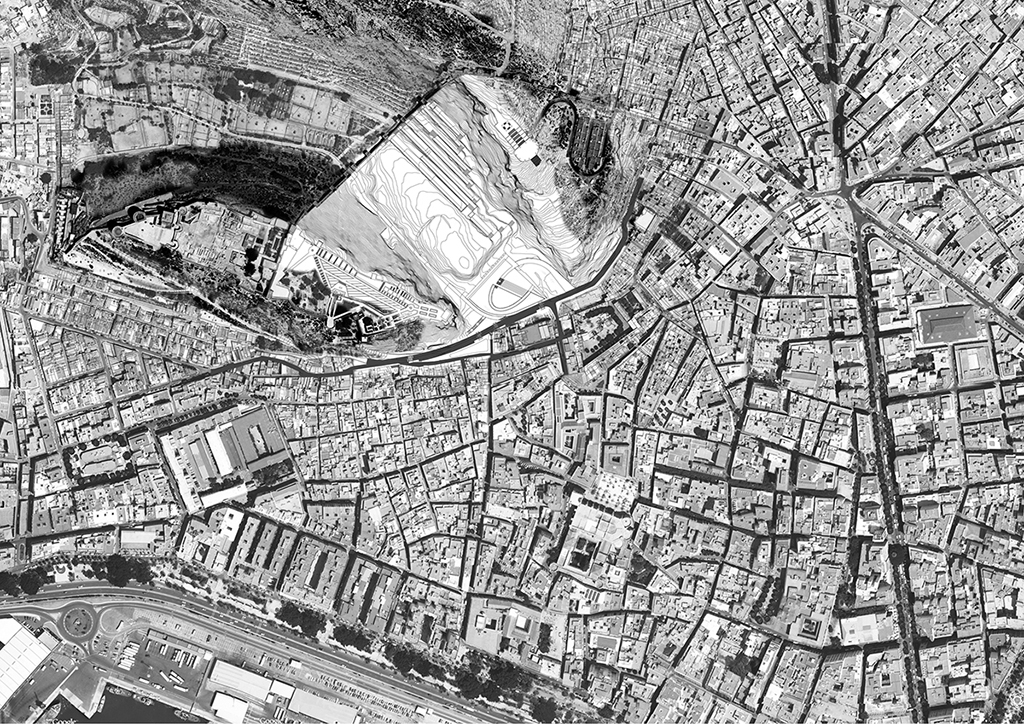
As expected the contest rules, the area of action has clearly divided into 2 subsystems, whose treatment architectural and landscape are quite different, while form an indivisible and complementary.
ZONE A. Urban-archaeological park.
This is an urban-archaeological park, whose size gives him a share of landscape-based criteria. Park serves as the coexistence of plant species (including wildlife) and visitors, spectators. Although in this particular area, the use of artificial irrigation paratas ditches, fed by wheel, basically attending to the cultivation of the vine, the proposal seeks a landscape more playful and less maintenance, but is intended to restore the system irrigation. In this sense, it is to recover species that are adapted to the climatic and soil characteristics of the region, whose range does not only encourage field trips and leisure stays, it serves as a laboratory and teaching and contextualized basis for scientific groups, academic or just interested.
The emerging archaeological remains, and its exploration and research, these systems are still active and it is difficult to determine a closed musealization. In any case, it seems interesting that the opening of new archaeological research could follow quite naturally from the different levels without interfering with the work themselves or organize tours when deemed appropriate, thereby supporting the work of dissemination.
Not considered appropriate building to anything, including park interpretation center provided in the statement of the contest.
The traffic system along the park is rotary and perimeter, ie, can be covered by longitudinal and transverse edges, leaving the center wilder and subject to possible changes.
Archaeological surveys:
1. East edge, GARDEN OF FLOWERS + GARDEN OF PALM AND PITAS. Paratas system, restored and suitable for movement and contemplation, is situated in the park at different heights (in meters):
+ 25.00
+ 27.50
+ 29.00
+ 31.00
+ 33.50
+ 36.00
+ 37.50
+ 39.50
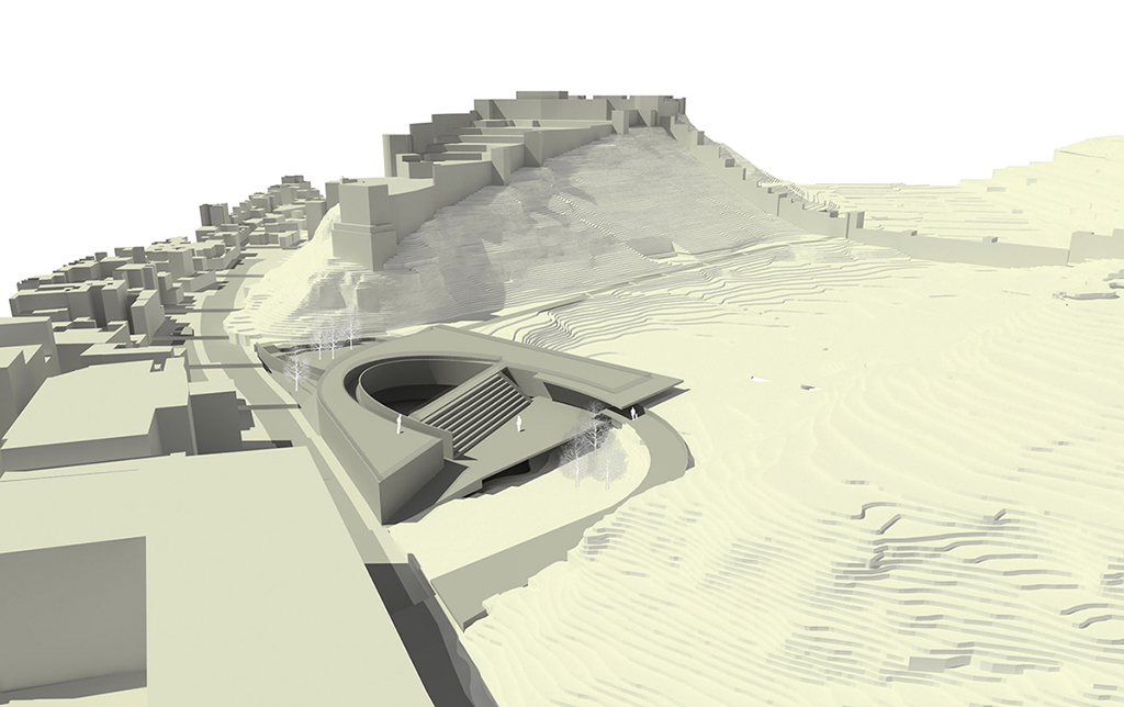
The organization respects the topography and existing native vegetation and endemic, adding new plants, which require some care and probably drip irrigation supplements. Its edges are marked by minimal areas of lush vegetation next to the stairs level change. These stairs act as refuges from the hard summer heat, as well as mark the diagonal that divides the study area and distribution of species, from another, more rugged and steep, whose species are more resistant, requiring less care on the part of gardeners and adequate facilities.
The construction components are very easy and they are part of scenic integrity. It provides:
1.1. Reconstruction of the walls of stone and mortar retaining weak, crowned by the canals rescued or rebuilt with reinforced concrete prefabricated sandstone color will be restored the flow of water throughout the system, irrigation serving more delicate species.
1.2. Wood plank paths 200x80 mm strips of the same section and bed material 150 mm thick gravel drainage.
1.3. Stairs and stretches of concrete slab with color molded sandstone, flanked by low walls, and banks of the same material.
2. North bank WALK AT THE BOTTOM OF THE WALL.
At the bottom of the wall of the 'Hoya', as a firewall, are located a series of small stairs, concrete color carved in sandstone, similar to the walls, linking the different paratas, down to the bottom of the 'Hoya' to climb back up to elevation 33.18 metres, where it joins the service road. Its role would allow the sweet road between memory, formalized by the huge canvases and contained nature, can touch both hands. A ride where the scales and magnitudes overlap, creating feelings of great pleasure.
3. West Bank GARDEN OF prickly pear.
Between the elevation +33.18 metres to +28.50 metres, There will be a 4 metres wide dirt road, required for the EEZA (Arid Zone Experimental Station) can enter within the Park Hoya and make possible visits to the Park Animal Rescue Saharan Africa. Alignment with firm clean ground, finished with wooden staves as footpaths of the terraces will serve as a longitudinal movement of the park by this margin. Its main attraction is in the enjoyment of the contemplation of the walls of Cerro de San Cristobal in all its glory, from a height and proper distance, while enjoying the smells and colors of plants more resistant.
4. VERTICAL GARDEN. South edge.
In this area, the original slope remains almost unchanged and therefore difficult to access. As a basis for the biggest constructive action, the cover rise between 1.50 m. and 3.00 m. from the current level, so that the top is continuous and artificial. A kind of hood that fits this gap of vegetation. From this position is where we can see the garden of endemic species.
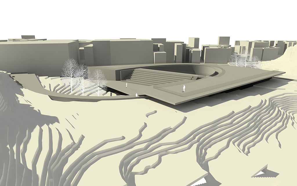
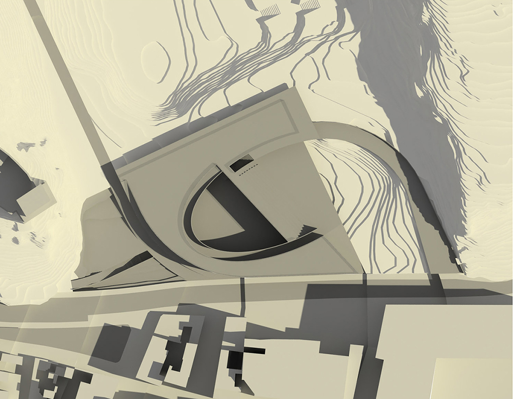
ZONE B. Link urban / Open space.
A complete project from circulation Urban Edge Round North, expropriating almost all of the set constructed in S. Christopher, to the north, as an extension of Granary Street, opens up new opportunities for the development of an area that has remained marginal and disjointed, because it is a difficult transition cap.
The current project includes the creation of a large open space, as a podium spot serves like amalgam of this complex space:
1. The east wall and the south towers of the Alcazaba to access (or output) for this area.
2. The wide front and front of the Hoya Wall.
3. The Hill S. Christopher, crowned also by its walls and towers.
4. The oldest established town in the city, linked by a strategic point of the Plaza de la Constitution.
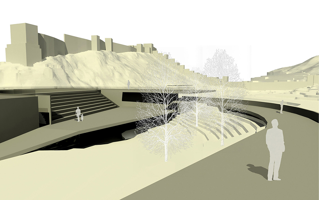
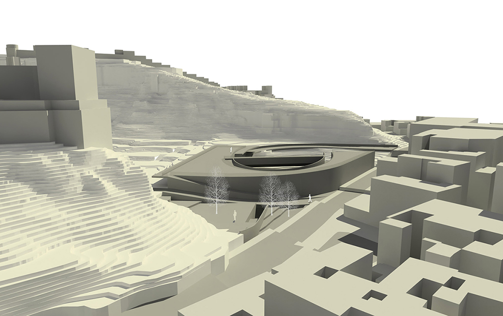
Under this platform of urban reference contemplation, a 2-storey building partially buried is developed, along the lines of the old neighborhood to demolish it also is protected by a retaining wall. The cover is located at elevation + 33.00 metres, so allowing visual permeability from any upper floor of buildings surrounding the new road, avoiding interference with the enjoyment of free space that is now placed on value while serving filter and control the same, although their access is direct and unrestricted.
The proposed building on this square is the visitor and interpretation center, which will serve as an educational resource and teaching, appealing to all ages, There will be various additional activities (courses, workshops, exhibitions, lectures, etc).
It is structured around a central courtyard open, semi-elliptical plan, and completed by the natural slope steep and rocky, which is now kept with all its trees. This form allows you to organized all the possible circulations, both horizontally and vertically, both into the building as close to the links. The structure:
The connection to the new road extension of Granary Street.
The connection to the slow lane of service to the Arid Zone Experimental Station.
The pedestrian connection to the park and its paratas-garden.
New connection to the Alcazaba and the footpath ramp.
The link to the town in one of its key points, determining the ratio compact city / urban landscape natural. The building consists of the following spaces and program development.
Floor(The spaces are located as the development dimension descending ramp elliptical):
1. Access / reception
2. Administrative area
3. Core protected elevators and escalators
4. Multipurpose workshops / showrooms temporary or permanent
5. Multipurpose Hall
Basement(Open to the elliptical courtyard and closed at its eastern side by the rocky and wooded natural slope that currently exists):
1. Cafeteria
2. Core protected elevators and escalators
3. Library / chill out
